Many who gaze at the beauty of the pond probably know little about the true purpose of this shallow man-made body of water that provides storage for stormwater and reduces local flooding.
Stormwater management plays a vital role in Albany, where paved surfaces and steep streets can send rainwater rushing into storm drains and nearby waterways. By slowing, filtering, and redirecting runoff, the city helps protect neighborhoods from flooding and keeps pollutants out of the Hudson River.
Buckingham Pond is a municipal stormwater management facility. It stores and retains stormwater—so preventing sewage flow into the Hudson and out of basements downstream of the pond—and helping keep the Hudson River, Albany’s communities, and local ecosystems and waterways healthier after storms.
The City of Albany maintains the park and works with the Albany Water Department to manage the pond and surrounding grounds. Parts of the main pond, the stilling basin to its west, and sections of the wooded area between the main pond and Rafts Way are federal wetlands, under the jurisdiction of the Army Corps of Engineers.
A Brief History
Once a part of the Town of Bethlehem (more about this in forthcoming Pond History & Stories), the pond was originally formed in the late 1800s when Beaver Creek was buried and incorporated into the city sewer system. Beaver Creek or Beaverkill, to use the Dutch word for creek, was one of five area kills that empty into the Hudson River. In 1931 the City of Albany authorized funds to grade and clear the area known as Buckingham Lake.
From 1988 to 1995, the City of Albany and Albany Water Department undertook a multiple phase project* to separate storm and sanitary sewers and direct stormwater from large parts of the surrounding neighborhood to a stilling basin constructed at the Davis Avenue end of Buckingham Pond. Read more about the impact of combined sewers in and around Albany, and steps being taken to reduce that impact.
How the System Works Today
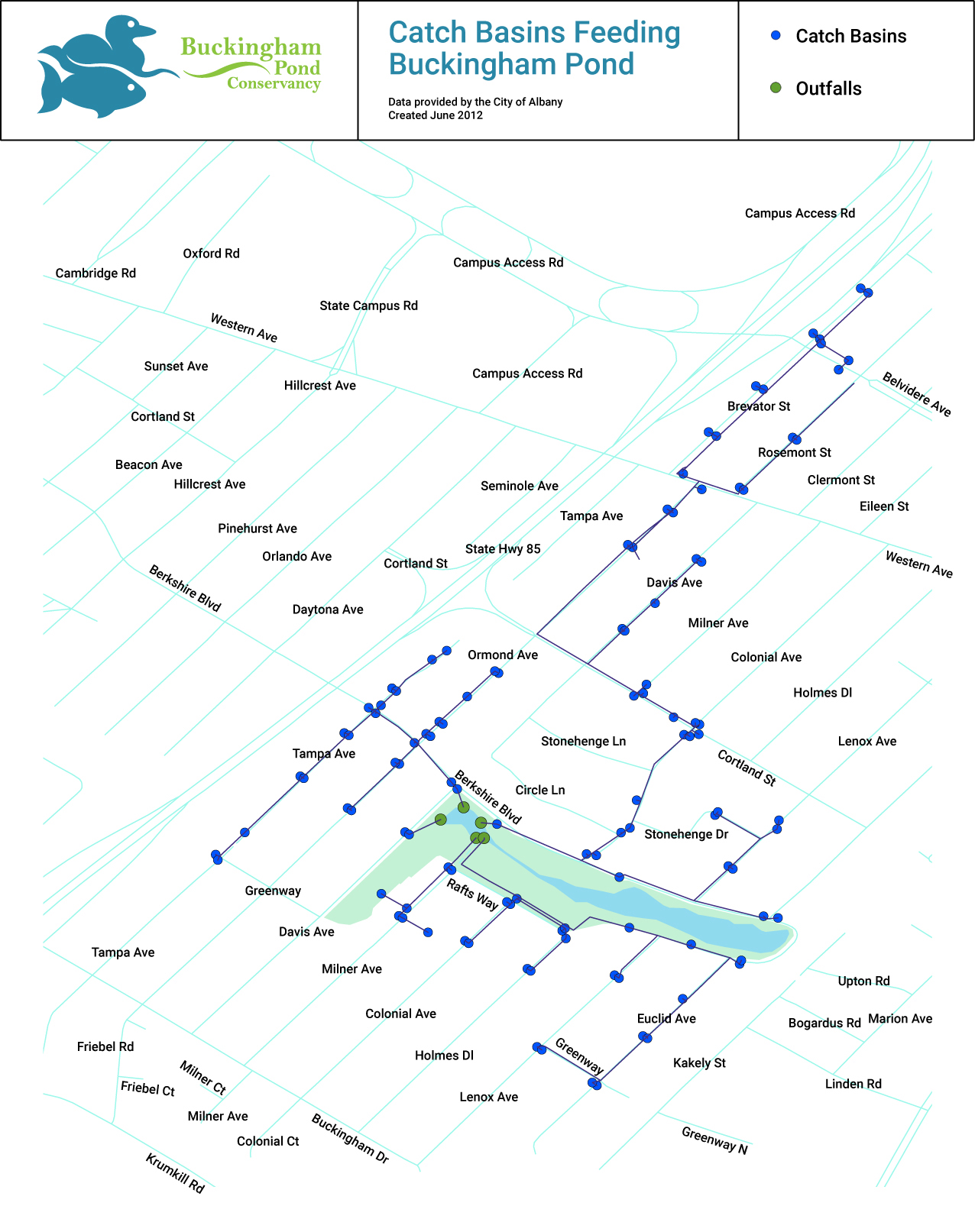
Rainwater from a nearly 265-acre watershed area is sent to stormwater drain catch basins and then diverted into the stilling basin. A pump in the stilling basin, controlled by a capacity sensor, moves water to a NYS drainage line that runs along the Route 85 Bypass, and from there to the Krumkill.
The City of Albany also uses the pump to manage the water in the pond, reducing its level before high impact storm events to provide additional storage capacity for storm water.
The pond is generally no longer allowed to take its original course flowing east to the Hudson. While there is a connection to the City’s Beaver Creek sewer system at the east end by Euclid Avenue, that overflow is set very high, and only allows water out of the pond in extreme flood situations. That reduces the impact of stormwater on the City’s overcapacity Beaver Creek sewer system and helps keep combined storm and sewer water out of the Hudson and out of basements in downstream neighborhoods.
Ongoing Challenges and Stewardship
As an urban water body, the pond is challenged by a number of issues, including pollution and human impacts. In 2014, Buckingham Pond Conservancy, in cooperation with the City of Albany, commissioned a Lake Management Plan funded in part by grants from the Hudson River Valley Greenway Communities Council and the Bender Family Foundation. The Lake Management Plan surveyed the biology, ecology, and water quality of Buckingham Pond and made recommendations for addressing areas of concern. The plan continues to form the basis of future prioritization and selection of projects undertaken by the Conservancy at the pond.
The Conservancy also conducts yearly water testing to assess water quality as part of the Citizen Science Lake Assessment Program thru the New York State Federation of Lake Associations and NYS Department of Environmental Conservation. The year 2025 marked our eleventh season of gathering this data and help guide further action.

The Conservancy manages the medallions at stormwater drain catch basins in the watershed.


Eutrophication
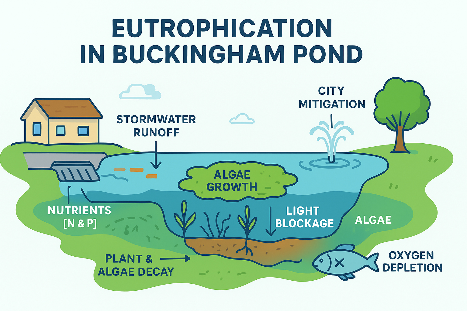
Stormwater from the surrounding 265-acre urban area brings nutrients into Buckingham Pond, which can fuel algae growth and cause eutrophication**—when a water body becomes overly enriched with nitrogen and phosphorus, upsetting its natural balance and ecology. The pond’s shallow depth (about 6 feet at its deepest) and limited natural circulation make it especially prone to algae and other water quality issues.
Because the pond collects water from a fully built neighborhood, everyday actions upstream have a big impact. Simple steps—like managing leaves, reducing fertilizer use, cleaning up after pets, and limiting runoff—help keep the pond healthier.
To improve water circulation in the pond and reduce algae, the City installed “aerator” fountains that also serve as decorative water features.
* Thanks to Daniel R. Hershberg, P.E. & L.S. of Hershberg & Hershberg Consulting Engineers and Land Surveyors for the 2009 presentation and research that is the basis for much of our knowledge of the pond history.
** New York State Federation of Lake Associations, Diet for a Small Lake, The Expanded Guide to New York State Lake and Watershed Management, 2nd ed. (New York: 2009), 17.
Looking for ways to help?
You can help ensure that Buckingham Pond is enhanced
for generations to come! Volunteer for events.
Become a BPC member. Donate. Join the BPC Board.
